Here's a link to my thesis, "Patterns of endemism and species richness of the Western Gulf Slope." Most of my research was concluded two years ago, and there will be some updates to later versions/publications. After many trials and tribulations I got it all done, and here it is.
Abstract
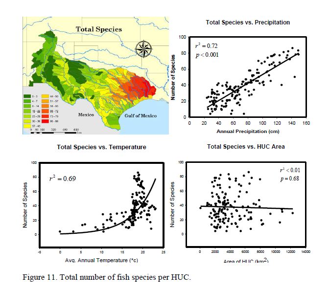
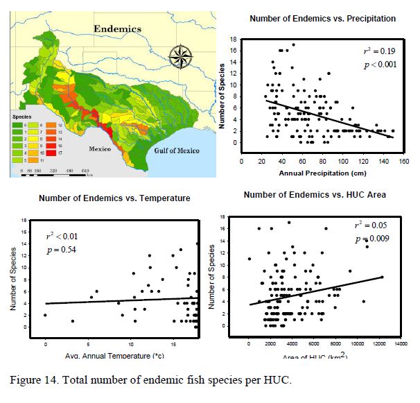
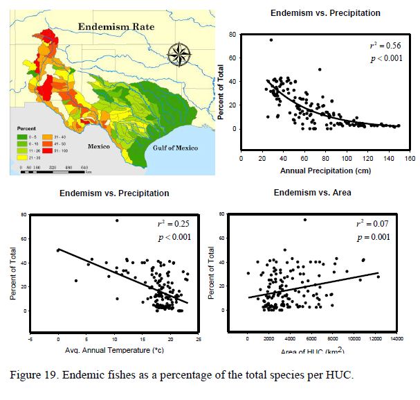
Contemporary freshwater fish communities are influenced by selection mechanisms (i.e., species-area relationships; species-energy relationships) with the role of historical mechanisms (i.e., speciation and dispersal) poorly understood and largely understated. I assessed the influence of selection and historical mechanisms on species richness and endemism among fish communities of the Western Gulf Slope (WGS). Distributions within the WGS generally conformed to predictions generated from global freshwater fish distributions. Species richness was greatest (P < 0.01) in wetter regions, and endemism was greatest (P < 0.01) in drier regions of the WGS. To assess historical mechanisms, fish phylogenies were used to determine direction, origin, and timing of dispersion into the WGS. Based on these findings, multiple events of colonization into the WGS likely occurred from the late Miocene until the start of the Holocene. Contemporary lineages represent ancestral origins and routes from the north (28% of the 155 native fishes of the WGS; beginning during the Late Miocene), southwest (15%; Late Miocene/Early Pliocene), north-east (14%; Pleistocene), and east (44%; Pleistocene through Holocene). Recent colonizers (north-east and east) attributed to the greatest numbers (67 to 93%) of widespread taxa within the WGS, whereas older lineages (north and southwest) attributed to the greatest number (92%) of endemics. Furthermore, greatest species richness was in the eastern WGS, nearest the source (e.g., Mississippi River) of most recent colonizers during the last glacial maximum. Consequently, historical influences obscured contemporary influences of selection mechanisms. Nevertheless, a consistent pattern of colonization and extirpation has emerged since the Late Miocene, which likely will continue to influence species richness and endemism in the WGS and can be used to inform fish conservation policy.
https://digital.libr...ndle/10877/4372
Patterns of endemism and species richness of fishes of the Western Gulf Slope - my thesis
Started by
Guest_rjmtx_*
, Dec 08 2012 09:15 PM
12 replies to this topic
#3
 Guest_rjmtx_*
Guest_rjmtx_*
-

- Guests
Posted 09 December 2012 - 05:04 PM
Hah... Let me think on that. I'll try to get something down within the next couple of days. I was told by my committee members that my Powerpoint presentation told the story much better than the manuscript, so I'll write something up more like I'd explain it in person.
#5
Guest_rjmtx_*
Guest_rjmtx_*
-
- Guests
Posted 12 December 2012 - 04:25 PM
Gerald, here's a translated abstract. I hope I clarified it a little bit, and I added what I think are the most dramatic figures showing richness and endemism. It's a very map-heavy paper, and they really tell a lot of the story on their own.
Fritz, I'd like to write an article when I get a chance, and will pm you some questions about it. It'll be a good chance to write something similar to how I would explain it to a friend or family member that's interested and not necessarily trained to read this gibberish (and keep their eyes open through it).
Freshwater fish communities are influenced by selection mechanisms such as species-area relationships (more species where there is more area to live in) and species-energy (more species where there is more available sun, nutrients, water, etc) relationships and historical mechanisms such as speciation and dispersal. Historical mechanisms are poorly understood, and in many studies of animal and plant communities, are understated. I assessed the influence of current factors and historical mechanisms on species richness (number of species) and endemism (number or percentage of species unique to the region) of fish communities in the Western Gulf Slope (WGS) from the Calcasieu River in Louisiana to the Rio Grande of Texas and New Mexico. Species richness was greatest in the wettest parts of the region (the east), and endemism was highest in drier areas (the west). I looked at evolutionary relationships of different species of fish, past geological events (i.e. rivers changing course), and current distributions of fish and their nearest relatives to determine the direction, origin, and time of the species’ arrivals the WGS. Based on my findings, there were multiple colonization events of fishes in the WGS, some of which had arrived by 4-6 million years ago, and some still probably arriving in significant numbers into the beginning of the Holocene (about 12,0000 years ago). Fishes from the north (28%) and southwest (15%) make up the oldest lineages, many of which have arrival time between 4 and 6 million years ago, but some continued to colonize the WGS in smaller waves more recently. Fishes from the east (44%) are the most recent arrivals in the WGS, largely invading throughout the Pleistocene (about 2.5 million to 12,000 years ago). Some species arrived with the early invasions from the north, and later with the invasions from the east (called north-east fishes in this study, 14%). Fishes with widespread distributions, which ranged beyond the WGS, were largely made up of eastern and north-east fishes, while the majority of endemics were from older lineages from the north and southwest. The greatest species richness was in the eastern drainages of the WGS, which are closest to the most recent source of colonizers, the Mississippi River. Historical influences did play a role in current fish distributions along with current environmental factors. There is a consistent pattern of colonization and extirpation (localized extinction) that has been going on for the past 6 million years or so, and continues to go on today. Knowledge of this pattern should be used to influence conservation policy.
#7
Guest_rjmtx_*
Guest_rjmtx_*
-
- Guests
Posted 12 December 2012 - 06:01 PM
Barring major geologic upheavals (which is why the northern and southwestern fishes' avenues of invasion were cut off 4 to 6 million years ago), the region gets wetter in glacial periods and the sea levels drop. With higher precipitation, drying events are lessened, erosion increases, and the possibility of a stream changing course or being captured by another rises. Also, the sea levels drop, so basins that are currently independent of each other connect in places that are now under the Gulf of Mexico (there's a picture of that in the manuscript). In the interglacial periods, the area becomes hotter and drier, and the sea levels rise separating the basins from each other. SO currently, we are in a drying cycle of increased extirpations (there is archaeological evidence suporing this, too), but once we get in the glacial part of the cycle, you can expect to see fish starting to recolonize the area (could be hundreds, thousands, or tens of thousands of years down the road). The current warming and drying cycle has been going on for the past 11,500 years or so (humans started to fiddle with agriculture with this warming cycle).
So, if/when we cool off again, and there are no major changes in the courses of the streams of the WGS, I'd expect most fish movement to be from the east to the west.
So, if/when we cool off again, and there are no major changes in the courses of the streams of the WGS, I'd expect most fish movement to be from the east to the west.
#8
Guest_AussiePeter_*
Guest_AussiePeter_*
-
- Guests
Posted 12 December 2012 - 08:11 PM
Is erosion higher during wet phases or dry phases? More veg when its wet can mean less erosion.
Also, is there any "real" evidence for stream captures in this region? Most of the change in stream gradients would be in the lowermost reaches as they try and get down to base level. It takes a pretty long time for this to alter gradients further upstream. If anything, things should be infilling some due to higher sea levels. For a lot of the Pleistocene sea levels were 30-60 or so meters lower. We are currently in one of the short high stands relative to sea level. Geologically though, most of the drainage basin boundaries seem pretty stable, and thus not too likely to have a whole lot of river capture going on.
Is the northern route really cut off? I guess in the headwaters of the Rio Grande it is to some extent, but north through Oklahoma there are lots of elements of the fauna that are shared with Texas.
Your study sounds like a lot of really great fun. I really like that part of the country, it is a great region for doing fish biogeography!
Cheers
peter
#9
Guest_rjmtx_*
Guest_rjmtx_*
-
- Guests
Posted 12 December 2012 - 10:13 PM
Yeah, there was an "Ancestral Plains Stream" that probably flowed from Kansas through what is now the Trinity, with the streams to the west flowing into it. Headward erosion up through the Edwards Plateau captured those streams along with headward erosion of the Pecos, which was once a small trib to the Rio Grande. Elbows of diversion are all over the region showing sharp turns of streams that were captured, and there is also sedimentary evidence. There are plenty of species found only in the Hill Country, and their distributions (and their life histories) are evidence of highland interbasin transfers. There's a good paper I cite on recent avulsions of streams in East TX and Southwest LA, which shows these processes are still very prevalent today. You also have to imagine the power of the Brazos as its mean discharge was 4x higher than it is today during the last glacial period. Shoot, the USACE does all it can to keep the Mississippi from diverting into the Atchafalaya, and where I live in SW LA was the mouth of the Red River in the Pleistocene, so yeah, one thing I learned in this research is that the rivers are dancing around and trading inhabitants all the time.
The northern route is not cut off, but I liken these invasion to a spigot. Up until around 4 mya, the northern route was flowing down to the WGS at full blast, but it was shut down to a trickle. I think that's what we're looking out throughout the region; multiple large waves with trickles in between.
The northern route is not cut off, but I liken these invasion to a spigot. Up until around 4 mya, the northern route was flowing down to the WGS at full blast, but it was shut down to a trickle. I think that's what we're looking out throughout the region; multiple large waves with trickles in between.
#10
Guest_rjmtx_*
Guest_rjmtx_*
-
- Guests
Posted 12 December 2012 - 10:21 PM
The manuscript isn't the smoothest read, but the info is in there. I'll try to get something written up telling a good story in layman's terms this winter. It really is a very sequence of events that led to the current distributions, and the current factors that determine the numbers and types of species across the region are pretty cool, too. Really, the take-home message I got from this is what a state of flux something we view as relatively static in our lifetimes as the placements of rivers and streams is constantly in. Another good example of a stream capture you can see on a map is the Navasota that now flows into the Brazos, but once flowed into the Trinity. That's one of the first examples of this phenomenon that I was told about years and years ago.
#11
Guest_AussiePeter_*
Guest_AussiePeter_*
-
- Guests
Posted 13 December 2012 - 12:29 AM
Yeah, there was an "Ancestral Plains Stream" that probably flowed from Kansas through what is now the Trinity, with the streams to the west flowing into it.
Has anyone who works in geomorphology ever said anything since the 1960's that supports that idea? Essentially all of those ideas seem to have largely come from Metcalf (a fish guy) in the 1960's, which all the fish people cite rather than citing any newer evidence for it. I talked with one geomorph guy who had studied the sediment from the lower Trinity and he said there was no evidence for an ancestral plains stream through the Trinity in "recent" times. I've not really dived into that literature though, but have always been curious to.
Elbows of diversion are all over the region showing sharp turns of streams that were captured, and there is also sedimentary evidence.
Elbows are very weak evidence for river capture. If you look closely enough at maps elbows are all over the place. In at least some examples studied the elbows follow faults rather than being reversals. Check out Bishop 1995, http://ppg.sagepub.c.../19/4/449.short
There are plenty of species found only in the Hill Country, and their distributions (and their life histories) are evidence of highland interbasin transfers.
Can fish only move between these regions via interbasin transfer? I've sequenced Campostoma from across that region and they are all pretty close to being identical, suggesting relatively recent contact between most basins. I'm not convinced though that river capture has been that extensive across the region to cause such extensive genetic similarity across the region. If it were then there should be more evidence for river captures happening today / or clearly poised to being captured.
There's a good paper I cite on recent avulsions of streams in East TX and Southwest LA, which shows these processes are still very prevalent today.
But that is in the flat lowland portion of the basins right?
Not trying to give you too much of a hard time on this stuff, I'm just an anti river capture kind of guy. River captures do happen, but they seem to me to be an overused (and abused) default explanation for fish biogeography without any consideration of alternative explanations.
Cheers
Peter
#12
Guest_rjmtx_*
Guest_rjmtx_*
-
- Guests
Posted 14 December 2012 - 10:47 AM
Here are some short answers since I'm trying to keep my toddler entertained (so excuse a few oversights and typos), and I like where this thread is going.
I need to look more into that. What did he consider "recent" times? Do you have citations for some of this?
Some of the evidence for highland captures is this theory of stream capture (and the timing for it) coupled with estimated divergence times. Pupfish and the endemic Cyprinella come to mind. The Dionda species (that might have invaded from the north to the south, and then spread back northward again), though I don't know of any estimated divergence times, are pretty old in the region.
I need to delve back into some of the lit I have. There's relatively recent ( a few 100k years) evidence of a Brazos to Red capture I remember reading about, and the lowland meanders and captures in the eastern part of the WGS are pretty regular. The speculation in the Western 2/3 of the region is thanks to the Balcones Uplift in the late Tertiary, which severely altered the landscape in ways we'll never know for sure.
OK, I'll try to carry on, but my boy has had enough of me on the computer for now.
Has anyone who works in geomorphology ever said anything since the 1960's that supports that idea? Essentially all of those ideas seem to have largely come from Metcalf (a fish guy) in the 1960's, which all the fish people cite rather than citing any newer evidence for it. I talked with one geomorph guy who had studied the sediment from the lower Trinity and he said there was no evidence for an ancestral plains stream through the Trinity in "recent" times. I've not really dived into that literature though, but have always been curious to.
I need to look more into that. What did he consider "recent" times? Do you have citations for some of this?
Elbows are very weak evidence for river capture. If you look closely enough at maps elbows are all over the place. In at least some examples studied the elbows follow faults rather than being reversals. Check out Bishop 1995, http://ppg.sagepub.c.../19/4/449.short
Can fish only move between these regions via interbasin transfer? I've sequenced Campostoma from across that region and they are all pretty close to being identical, suggesting relatively recent contact between most basins. I'm not convinced though that river capture has been that extensive across the region to cause such extensive genetic similarity across the region. If it were then there should be more evidence for river captures happening today / or clearly poised to being captured.
Some of the evidence for highland captures is this theory of stream capture (and the timing for it) coupled with estimated divergence times. Pupfish and the endemic Cyprinella come to mind. The Dionda species (that might have invaded from the north to the south, and then spread back northward again), though I don't know of any estimated divergence times, are pretty old in the region.
Not trying to give you too much of a hard time on this stuff, I'm just an anti river capture kind of guy. River captures do happen, but they seem to me to be an overused (and abused) default explanation for fish biogeography without any consideration of alternative explanations.
Cheers
Peter
I need to delve back into some of the lit I have. There's relatively recent ( a few 100k years) evidence of a Brazos to Red capture I remember reading about, and the lowland meanders and captures in the eastern part of the WGS are pretty regular. The speculation in the Western 2/3 of the region is thanks to the Balcones Uplift in the late Tertiary, which severely altered the landscape in ways we'll never know for sure.
OK, I'll try to carry on, but my boy has had enough of me on the computer for now.
#13
Guest_AussiePeter_*
Guest_AussiePeter_*
-
- Guests
Posted 16 December 2012 - 10:48 PM
I need to look more into that. What did he consider "recent" times? Do you have citations for some of this?
I checked back through my email on this, but figured out that I was wrong, in that the guy I contacted didn't really know whether the Trinity would have been the outlet for the Red earlier in history, was beyond his study areas.
Some of the evidence for highland captures is this theory of stream capture (and the timing for it) coupled with estimated divergence times. Pupfish and the endemic Cyprinella come to mind. The Dionda species (that might have invaded from the north to the south, and then spread back northward again), though I don't know of any estimated divergence times, are pretty old in the region.
The pupfish stuff from Echelle's paper was all pretty vague about drainage changes, didn't see anything in the Dionda or Cyprinella papers I have (Schonhuth et al. 2010, 2011). Dionda seem a bit funky biogeographically as they often seem to have restricted allopatric ranges within river basins. Same with some of the Cyprinella too.
I need to delve back into some of the lit I have. There's relatively recent ( a few 100k years) evidence of a Brazos to Red capture I remember reading about, and the lowland meanders and captures in the eastern part of the WGS are pretty regular. The speculation in the Western 2/3 of the region is thanks to the Balcones Uplift in the late Tertiary, which severely altered the landscape in ways we'll never know for sure.
I couldn't find anything specific about the age of the Balcones uplift, but I think that was pretty old. I did see mention of the Llano uplift, but that was still 10 million or so years ago.
cheers
Peter
Reply to this topic


0 user(s) are reading this topic
0 members, 0 guests, 0 anonymous users

