Jump to content


Photo

Rock Creek


16 replies to this topic

#1 Casper

Casper
  • NANFA Fellow
  • Chattanooga, TN alongside South Chickamauga Creek, just upstream of the mighty Tennessee River.

Posted 28 July 2015 - 02:29 PM

Rock Creek


Years ago i enjoyed this site but then something disturbing happened to it.  On my first visits it was a coarse cobbled flowing stretch of clear water full of Hogsuckers and various Darters, but upon subsequent returns it had turned into a flowing silt pool, miring in deep mud with any attempts to wade in.  Rock Creek flows off the plateau in a dramatic waterfall and then races over tumbling boulders during major rain events.  Perhaps property development or clear cutting was involved on the plateau, what ever the cause i had given up on it the last few years.

I had been skunked on a drive to the north a couple Sundays ago so headed south in hopes of finding clear water.  I stopped at the bridge and looked over to see the sand but also several schools of Minnows, Sunfish and a few Suckers in the clear 3 or 4' deep water.  Excited i worked down the slippery muddy bank beneath the bridge and stepped off thinking i was going to sink to my knees but instead was met by firm coarse sand.  Several Black Spotted Topminnows came to greet me as i waded to thigh deep water and kneeled down acclimating me to the suprisingly chilly water.  It was reasonablely clear and and i soon found a cloud of shiners gathered behind me feeding upon the disturbed dietris.


00-RockCreek-Down.JPG


01-RockCreek-Up.JPG


02-Collage.jpg


Upstream is what interested me, flowing water over a log jam against the bridge's columns.  This is where the fun stuff gathers.  The water was gently flowing over an angled log with the sloping sand swept clean below it.  Hundreds of Snubnosed Darters were gathered in the flowing pool and the adjacent sides which were littered with all manner of woody debris.  Suprisingly also among the Snubs were a pod of Dusky Darters.  I had seen them years before downstream but it was especially nice to see such a large group here.  I began to make out the schools of minnows, the ones swimming low over their favored habitat were Bigeye Chubs and higher in the column were hundreds of Striped Shiners.  I was quite pleased to see so much life here and the proper species for this habitat.


03-Snubs.jpg


04-Dusky.jpg


05-Chubs.jpg


06-Nest.JPG


I explored around the quieter pools to the sides and found a Redbreast Sunfish sitting on a saucer shaped nest.  Nervous he would flee upon every approach, no matter how slow and easy i was.  Getting close i noticed instead of the coarse sand his nest was lined with fine gravel, a bit of a surprise considering what i have been seeing over the years.  I took a few photos of his nest but could not detect any movement of fry nor eggs.


As i was enjoying the experience a chattering couple walked down under the bridge and were soon wading upstream past the log jam, of course mucking up the limited visibility i was enjoying.  I thought about asking them not to but instead floated downstream into the woods were i encountered another log jam with surface scum backing up, never appealing for a snorkeler.  I didn't really see much of anything but some bass lurking in the shadows.  After a bit of frustration i returned to the bridge where the couple had gotten out.  I poked around a bit watching a few Rainbow Darters in the quiet areas before getting out and approaching the couple.  I always enjoy people's expressions of bewilderment when they see the soggy beast rise out of the water.  She said they were looking for some kind of swimming hole her daughter had spoke of but i could think of any swimming hole in the area... which of course i would be interested in.  They were pretty confused all things considered and soon returned to their car.


With their departure i decided to return to the van and drive upstream to a railroad crossing.


07-ErosionRR.JPG


Casper Cox
Chattanooga, near the TN Divide on BlueFishRidge overlooking South Chickamauga Creek.

#2 Chasmodes

Chasmodes
  • NANFA Member
  • Central Maryland

Posted 28 July 2015 - 03:07 PM

Great report Casper!


Kevin Wilson


#3 Isaac Szabo

Isaac Szabo
  • NANFA Member
  • Marble Falls, AR

Posted 29 July 2015 - 10:53 AM

I'm glad it seems that the site may be recovering.


#4 Casper

Casper
  • NANFA Fellow
  • Chattanooga, TN alongside South Chickamauga Creek, just upstream of the mighty Tennessee River.

Posted 03 August 2015 - 05:07 PM

Saturday Return  
 
 
00.jpg
 
There is a dead man in the creek.


01-BridgeView.JPG
 
Clear water beckons.
 
Last week i had told visiting Rob about the Rock Creek experience and he promptly drove off the mountain a few days later to check it out for himself.  His response was "Stellar!".  Now i do not use that word often and we determined to meet up there Saturday about noon and see if things had changed during the last week or so since my visit.  I was the first one in and was soon mystified as to why i was not seeing near the quantity of fish i had on my recent visit.  The water was flowing a bit more but only by an inch or two over the log jam.  The water was still clear but only a few Snubs were seen in the sloping sand run and no Duskys appeared though i looked long and hard through the woody debris.


02-UnderBridge.JPG
 
No Trolls.


03a-Snub.JPG
 
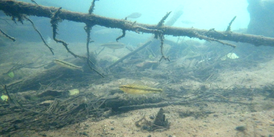
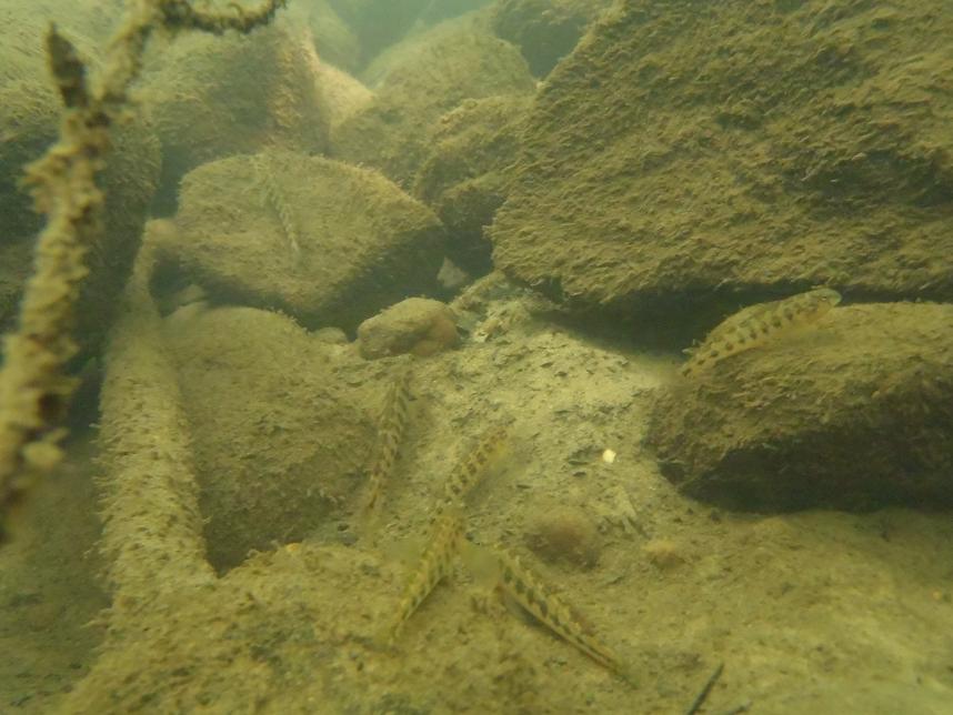
Fleeing Caudal Spots
 
Around here we have two forms of Snubs, Tennessee Snubnose Darter and the Black Darter.  A trained eye has difficulty discerning the two species and i have given up long ago.  Something about a frenum and the two center caudal spots fusing.  Blacks are more common in plateau streams and smaller urban springfed streams.  You tell me, and you can clearly see the two center caudal spots are NOT fused.  As for a frenum they gotta be dead done gone.  They are the most common species encountered around here and seem to do well in a variety of habitats.  They are most handsome in the early spring when the water is cold cold.


03-Fry.JPG
 
A bit blurry but many are home.
 
Off to the side i reapproached the Redbreast nest and again the male fled.  I studied the textured surface but could see nothing unusual but snapped a few photos anyway.  After looking close at the blurry photos on my studio monitor i can see many transparent globes with tails, larval sunfish!  This Daddy was not doing a good job of protecting his offspring!


04-SpringBoils.JPG
 
Spring Boil.
 
Rob headed a good ways downstream while i played near the bridge chasing Rainbows and Bigeyed Chubs.  When he returned and reported nothing but more log jams, stagnant water and a few Hogsuckers we decided to wade upstream as he had done alone a few days before.  Crossing above the log jam i soon saw where the larger schools of Chubs and Shiners had moved to, i suspect using the slightly higher flow allowing the transition.  After patrolling the quiet log jam pool we waded upstream and found a nice graveled run, long and deep enough for us to snorkel crawl up to the head.  Ideal in its structure and full of life but too shadowed for photos, i did catch a quick glimpse of some type of juvenile Sucker adding another species to the growing list.
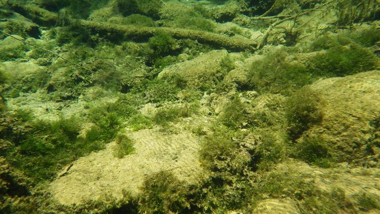
Continuing on we came to the spring seeps i had recalled from years before.  Gentle multitudes of little geysers danced sand particals into tiny plumes.  Sand boils welled up from the clean sand amongst the lush mossy growth covering the larger stones.  The water rippled in the sunlight where the cold spring water mixed with the warmer water flowing from upstream, creating a shimmering effect.  This is where the creek gets its steady flow from, making ideal snorkeling conditions downstream.  Tracking down spring locations is a rewarding activity in this region.  Not surprisingly many springs are found erupting from the rock bones of streams


05-RobRR.JPG
 
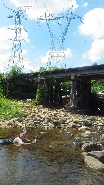
We will snorkel just about anywhere clear.


06-RobPower.JPG
 
Rob beneath the crackly wires and in the tingly water.
 
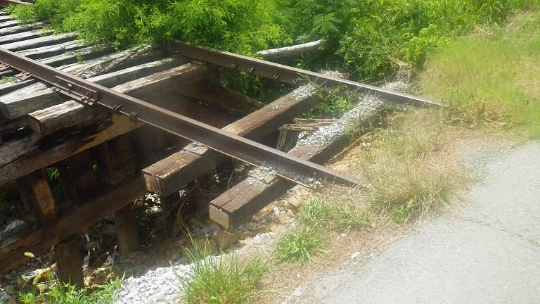
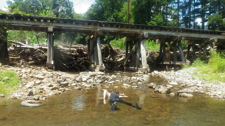
After 2 or 300 yards we arrived at the railroad crossing where another log jam was pushed up high against the massive timbers, redirecting surging storm flows to the right which had washed out the land from under several railroad ties and now progressing into the road as well.  Surely this track is no longer used and authority's eyes are observing the situation.  I would think a team of railroad chainsaw wielders would set upon this woody jam and relieve the pressure upon their investment.  But for now, water clear and a bit warm gently flowed out from under the jam as a beautiful narrow rivulet filled with a variety of fish whom were gathered in the outflow.
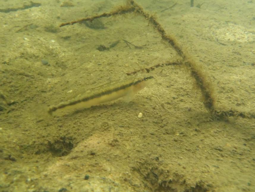


07-RBD.JPG
 
Rainbow Darter.
 
Rob wanted to continue on beyond the bridge but i thought better of it and stayed behind to tease out photos and enjoy the site below.  I eased into the outflow as much as comfortable and twisted my head to see a school of Stonerollers grazing on the algaed rocks to my right.  Twisting a bit more i could see Gambusia at the surface.  To my left were Bigeye Chubs mixed with Striped Shiners, and directly ahead were the Darters.  I moved the poking rocks from my belly and cleared away a few bigger stones directly ahead of me and flushed out the bits of silt and debris.  Soon this little concave wash was being visited by Rainbows and Snubs hunting the freshly exposed substrate for teeny tiny morsels.  I hoped to see a Redline, a specie that i recalled from years before but after about 30 minutes none were observed.


08-Darters.JPG
 
The same with a pair of Snubs.
 
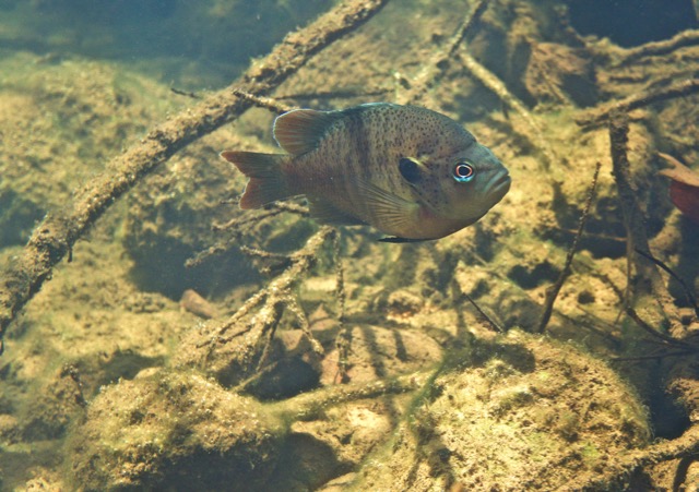
I moved down stream to a nice log to rest and remove sharp gravels from my Keens, an awkward affair. I eased back into the water and rested my chin on the slick log and could clearly see all manner of fish swimming just below the surface on the other side of the log.  I relaxed, near motionless and let time pass marveling at the Sunfish school made of Bass, Redbreasts and Bluegills clearly defined as they passed to and fro.  Mixed amongst the Sunfish was a lone Hogsucker swimming back and forth as if he too was a Sunfish.  I could clearly observe every detail on his body from his black flag dorsal to his sucker mouth and various patterns on his back and sides.  And with the fish was a large lone Stoneroller, also swimming with the Sunfish school.  I considered it odd and thought they must feel lost from their kind, but trying their best to fit in.
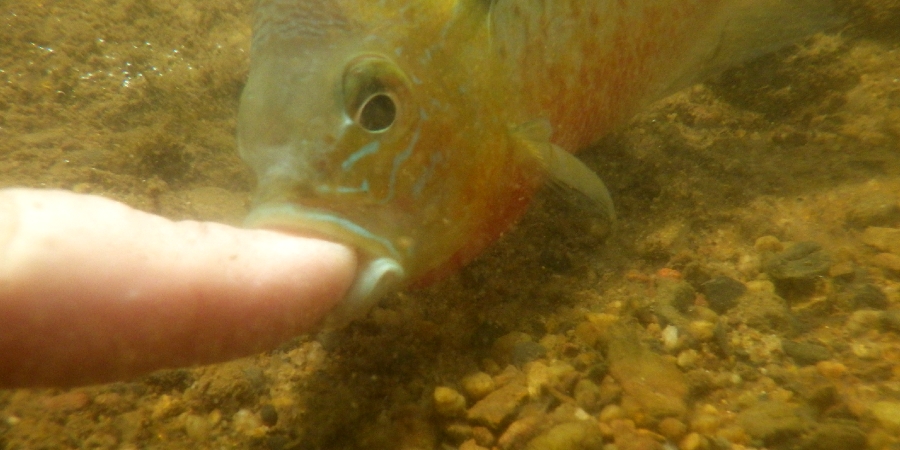
I noticed a saucer nest just up from me and straddle crossed the log and eased back in and up to the nest's edge.  Sure enough out of the haze the Redbreast came forward to see the big eye before him.  I eased a finger in and he backed off just a bit but stayed close.  I teased the sand and he came forward to inspect the activity and nudged my finger.  I diddled in the sand a bit deeper and he nipped at my pinky. The longer i gently teased the more aggressive he became and was soon not only pecking at me but outright biting and then biting hard and holding on tight!  I looked up to see Rob clammering down from the railroad log jam and figured i had one good chance.  The next time the Robin bit and held i would push is chin into the gravel and sweep my other hand over, cup and catch him for a real live action photo. Quicker than me he slipped out in a flash and that was enough for him and me.  While i told Rob of the affair and caught up with his upstream adventure the Robin did not make a reappearance.  A nice hand photo would have made the story better indeed.
Rob had interesting news as he found a series of bouldered pools above and reported a Spotted Sunfish being the apex Sunfish, a dark whiskered Catfish deep in the shadows and most surprisingly, a Yellow Perch.  We only rarely see Yellow Perch here and they are always associated with cold water be it springs or minimal flow dam releases.


09-Sunny.JPG
 
The Robin


10-Bite.JPG
 
The Robin Bites
 
By now we had stirred the water up quite a bit and returning downstream we just slowly waded through the cloudy water.  My pinky needed a bandaid and Rob was sunburnt red in his Farmer John yet shivering from the chilling spring water so we decided enough was enough and drove back to St. Elmo for some Mojo Burrito and fresh made guacamole.
 
Rob has been using a digital SLR in an underwater case.  Viewing his edited photos on his laptop has been impressive indeed.  Hopefully he will share some of them and i will add those photos to this account along with the CNF Conasauga outing he accompanied me on.


Casper Cox
Chattanooga, near the TN Divide on BlueFishRidge overlooking South Chickamauga Creek.

#5 Josh Blaylock

Josh Blaylock
  • Board of Directors
  • Central Kentucky

Posted 04 August 2015 - 08:16 AM

Is this Rock Creek, part of the BSF, if so, were you in TN or KY?


Josh Blaylock - Central KY
NANFA on Facebook

KYCREEKS - KRWW - KWA


I hope to have God on my side, but I must have Kentucky.

- Abraham Lincoln, 1861


#6 Casper

Casper
  • NANFA Fellow
  • Chattanooga, TN alongside South Chickamauga Creek, just upstream of the mighty Tennessee River.

Posted 05 August 2015 - 01:24 PM

Georgia.  Every state has at least one Rock Creek i would suspect.


Casper Cox
Chattanooga, near the TN Divide on BlueFishRidge overlooking South Chickamauga Creek.

#7 Casper

Casper
  • NANFA Fellow
  • Chattanooga, TN alongside South Chickamauga Creek, just upstream of the mighty Tennessee River.

Posted 27 August 2015 - 05:22 PM

Robs Photos & Jeremy's visit.
 
Rob sent me a few images and these i will share.


01-Rainbow.jpg
 
Bright light Rainbow.


02-Dusky.jpg
 
Woody debris dweeling Dusky.


03-Spotted.jpg
 
Shadowed Spotted.
 
Jeremy was in town showing his films and sharing a panel session at the 2015 Aquatic Biodiversity Network.  I am glad to relay that his projects are moving along and big plans are in the future.  His work is being imbraced by those that can provide the funding that his work so wonderfully celebrates.  After the event we spent the afternoon relaxing and wondering on a country ride.  A snap of him on the precarious railroad tracks.
 
 
00-JeremyRR.JPG
 
No snorkel but we saw a herd of big 1 foot plus Hogsuckers that had moved up to the bridge.  Maybe i can make another dip before the season ends.  This creek flows to Chattanooga Creek, one of the most notorius polluted superfund sites but up here the water is springfed clear.
 

Casper Cox
Chattanooga, near the TN Divide on BlueFishRidge overlooking South Chickamauga Creek.

#8 Casper

Casper
  • NANFA Fellow
  • Chattanooga, TN alongside South Chickamauga Creek, just upstream of the mighty Tennessee River.

Posted 04 August 2016 - 05:05 PM

Rob put together a 10 minute video compiled from his visit last year, 2015.  We did 2 sites together and he the third alone.

The first portion is the Conasauga River.

The 2nd is Rock Creek which is the topic of this posting.

The 3rd is Crawfish Creek which is just a bit south of Chattanooga near the AL / GA line.


He told me this would only be up for a couple weeks, so enjoy while you can.  YouTube kicked it off because of some of the music.


https://drive.google...YTVZUTNPMjh1M2M


Casper Cox
Chattanooga, near the TN Divide on BlueFishRidge overlooking South Chickamauga Creek.

#9 Isaac Szabo

Isaac Szabo
  • NANFA Member
  • Marble Falls, AR

Posted 05 August 2016 - 10:45 AM

Nice video! I enjoyed watching it.


#10 Chasmodes

Chasmodes
  • NANFA Member
  • Central Maryland

Posted 05 August 2016 - 11:24 AM

Awesome!  I was going to skim through it and watch it later, but I couldn't stop watching :)


Kevin Wilson


#11 qualiajunkie

qualiajunkie
  • NANFA Guest
  • Boston

Posted 05 August 2016 - 11:47 AM

Wow, looks great! Makes me want to start a native stream tank.


#12 Casper

Casper
  • NANFA Fellow
  • Chattanooga, TN alongside South Chickamauga Creek, just upstream of the mighty Tennessee River.

Posted 08 August 2016 - 02:24 PM

Rock Creek Sunday, August 7 2016
 
It has been a year since i last snorkeled here and that had been a somewhat pleasant surprise.  Today was disappointing, as the creek should be renamed Sand Creek.  Studying the exposed banks i could see all the rounded rocks strata layered, but in the creek bed, sand had buried near all the rocks.  I still cannot tell where the sand is coming from.  Upstream a mile or so, to the foot of Lookout Mountain a high waterfall feeds the creek, but only in wet weather.  Otherwise the creek is fed by springs, one of which is located between the 2 bridges, a rocky outcrop lush with clean stones covered in a dark green moss.  The spring water flow was about 60 degrees, a bit chilly but refreshing on this hot day.
 
From the bridge i could see about a dozen Hogsuckers working the sand run downstream and from the other side looking upstream i could see two schools of minnows along with a few Blackspotted Topminnows patrolling the creek's shallow edge.  I decided to give it a try.
 
From within the water the visibility was murkier than it appeared from above and everything was covered with silt.  When stones are buried by sand and silt lays heavy i do not expect much life.  Years ago every square foot of the creek's bottom was alive with crawdads and insects living under the rocks, not so these days.  Crossing above the dam snag i saw that the minnows were for the most part Bigeye Chubs which tend to enjoy sand runs.  The are a simple, pretty elegant fish that i enjoy seeing with their upward puppy dog eyes. Snubnose Darters were common, darting from spot to spot, a few still in nice color and one female appeared gravid.  A few Striped Shiners swam by, eager Smallmouth Bass alert for a snatch and various Sunfish were in the mix.  A couple big Crayfish fluttered by as Hogsuckers lay still hoping i would not disturb them.  Stoneroller herds made a few passes, stopping to graze here and there.  Life appears to be thriving but not the same diversity i enjoyed in the past.
 
I walked upstream through the shallows stopping to snorkel in different pools created by wood snags.  I was surprised to see a dark Sculpin waiting in ambush.  Generally they need rocks to hid under and there were few available.  I thought he might be the last of his kind.  A pleasant find was a pair of large Dusky Darters hanging around a submerged snag, just like their cousins the Blackbanded Darters of systems southward.  My camera was not sensitive enough to capture crisp images in the shadowed light but i selected a few to share the day's account.
 
 
10-Bridge.JPG
 
A bit of trash, a tire, a car battery... the general refuse from southern society.  Still worthy of a quick look below the surface.
 
 
11-Snubs.JPG
 
Formerly Tennessee Snubnosed Darters seen in Georgia.  There were plentiful and scatter darted forward with every advance.
 
 
12-Sculpin.JPG
 
The Sculpin, perhaps the last king awaiting another meal.
 
 
13-Dusky.JPG
 
Dusky, cousins to the Blackbanded.
 
 
14-RRBridge.JPG
 
The bridge's near road washout to the right, now reinforced with a new load of gnarly, sharp stone.  The massive log jam has been removed, probably done with heavy equipment.  To continue exploring upstream would require a full day of exploring.  In past creek walks after a couple to three hundred yards the stream's flow dries to shallow pools and then a dry river rocked stream bed all the way to the mountain's base.  I have seen massive Sucker runs occur here in the distant past, so a Springtime return trip is overdue.
 
Now if all the sand and silt could be blown downstream.


Casper Cox
Chattanooga, near the TN Divide on BlueFishRidge overlooking South Chickamauga Creek.

#13 Isaac Szabo

Isaac Szabo
  • NANFA Member
  • Marble Falls, AR

Posted 09 August 2016 - 11:28 AM

That's too bad. Do you think the drought in your area has contributed to the sand/silt and that the next high water event might flush it out?


#14 Casper

Casper
  • NANFA Fellow
  • Chattanooga, TN alongside South Chickamauga Creek, just upstream of the mighty Tennessee River.

Posted 10 August 2016 - 10:49 AM

I do not see how the drought, which continues on now to 11.5", could influence the addition of silt and sand.  Although sparse vegetation could die, such as in a plowed field, leaving the soil exposed, ready to be washed in at the next rain event.  And when a gully washer does occur it may well blow out the sand that has gathered here at this site but also bring tons more upon it.

It is sad to see the impact our activities have on the watery worlds we cherish.

But as noted other species like the Bigeye Chubs and Snubnoses take advantage of the "new" conditions.

I will go back next Spring and give it a look and make the walk to the waterfall.  I bet there is a lot of exposed earth near the base.


Casper Cox
Chattanooga, near the TN Divide on BlueFishRidge overlooking South Chickamauga Creek.

#15 Isaac Szabo

Isaac Szabo
  • NANFA Member
  • Marble Falls, AR

Posted 17 August 2016 - 04:33 PM

I was just wondering if perhaps it's not that more silt/sand is entering the stream but rather that the normal amount of silt/sand in the stream is accumulating to an abnormal level since there haven't been recent high water events to flush it downstream. But who knows, it could be one or the other or both.


#16 Matt DeLaVega

Matt DeLaVega
  • Forum Staff
  • Ohio

Posted 17 August 2016 - 05:37 PM

I was just wondering if perhaps it's not that more silt/sand is entering the stream but rather that the normal amount of silt/sand in the stream is accumulating to an abnormal level since there haven't been recent high water events to flush it downstream. But who knows, it could be one or the other or both.

Conundrum


The member formerly known as Skipjack


#17 Casper

Casper
  • NANFA Fellow
  • Chattanooga, TN alongside South Chickamauga Creek, just upstream of the mighty Tennessee River.

Posted 18 August 2016 - 02:03 PM

I forgot about the value of Google Earth though have been frustrated in using it during the last hour.  But it does allow me to have an eagle eye.


https://www.google.c...m/data=!3m1!1e3


I see a wide power line actively used by 4 wheelers with lots of weaving exposed dirt trails.  Any runoff leads directly to the creek  I see what appears to be some kind of horse arena, potentially acres of exposed earth.  Hard to see the waterfall or the mountain's steep brow but i am surprised how far the creek and tribs meander on the plateau.  I wish i could overlay contour lines but cannot find that option.  I do see and note a 1 mile creek walk that perhaps i can do before the season ends, which might expose either of the 2 noted possible erosion sources.


But in response as i have stated... this creek was very clean, boulder rocked for my early years of snorkeling.  Now it is sandy silted mirred.  Obviously a name change is needed.  ( a sad wink. )  Several probable culprits appear, as always a factor in man's ongoing "development".  Yes a big rain may well wash out the current sand and silt but will likely only bring much more in from above... wherever the multiple(s) source(s).


This is a common sadness one often encounters.


Casper Cox
Chattanooga, near the TN Divide on BlueFishRidge overlooking South Chickamauga Creek.


Reply to this topic


0 user(s) are reading this topic

0 members, 0 guests, 0 anonymous users