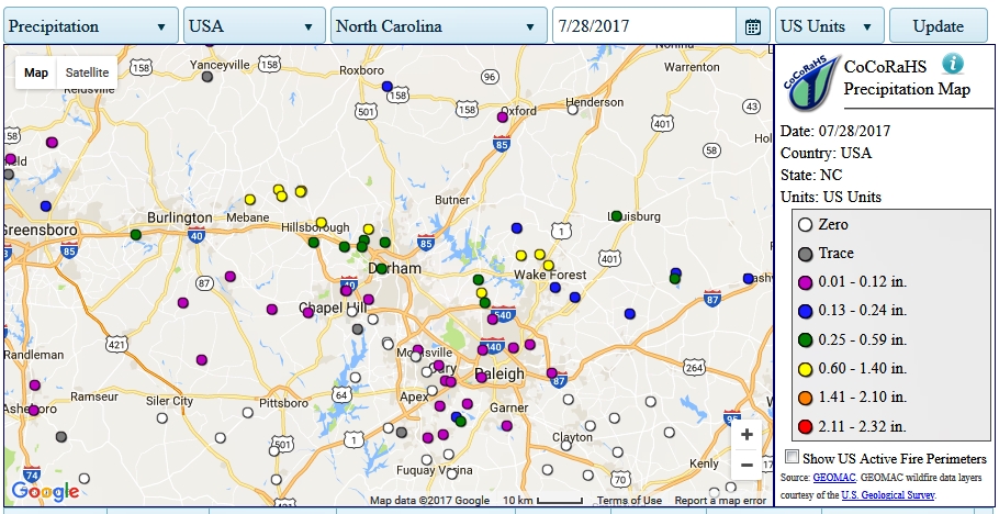
The Community Collaborative Rainfall, Snow and Hail Network (CoCoRaHS) consists of thousands of sites across N.America where volunteers report their local rainfall for the past 24-hrs each morning. It's helpful for planning field trips and assessing stream conditions, used in conjunction with USGS stream gauges. Data are shown as color-coded dots on a map, and you can also download past data for any gauge and any time period. Being volunteer-run, monitoring sites come and go, and there can be data gaps when somebody is out-of-town or just not reporting their gauge, but there's so many sites in most places that there's usually some active ones close enough to be useful. Since CoCoRaHS data are reported each morning, rainfall peaks may appear a day later than NWS, USGS, and other rain gauges that report midnight-to midnight. For example, the heavy rainfall we got between 8 to 11 pm last night (July 27) will be reported as July 27 on NWS and USGS sites, but as July 28 on CoCoRaHS. Here's today's map (July 28) for the Raleigh-Durham NC area, which reflects rainfall from ~ 7am July 27 to 7 am July 28. Wake Forest and Durham got soaked pretty good, but nearby Raleigh, Chapel Hill, and Oxford just got a sprinkle.

Rainfall Mapping, CoCoRaHS
Started by
gerald
, Jul 28 2017 09:22 AM
1 reply to this topic
#2

mattknepley
-

- NANFA Member
- Smack-dab between the Savannah and the Saluda.
Posted 29 July 2017 - 04:14 AM
That could be pretty useful used with USGS stream guages. Gives you a pretty clear line where the rain was and wasn't in this case to be sure.
Matt Knepley
"No thanks, a third of a gopher would merely arouse my appetite..."
"No thanks, a third of a gopher would merely arouse my appetite..."
Reply to this topic


1 user(s) are reading this topic
0 members, 1 guests, 0 anonymous users

