I'm working on a project for my Great Lakes Ecosystems course here at Bowling Green State University. My professor has asked me to do a pretty open ended project. He asked me to do a project that relates to the Great Lakes. Naturally, I leaned towards a fish project. I decided to document fish populations in different areas of the Portage River Watershed. I'm going from headwater streams - all the way down to the river's confluence with Lake Erie. So, in essence, I'll be going out to all kinds of spots in the Portage River watershed, collecting fish, and reporting about it. Good times! For those of you not familiar with the Portage River (probably most people not in Ohio), here's some background info;
The Portage River is found in Northwestern Ohio. It drains a significant portion of that part of the state. Much of the watershed runs through very low-gradient (no hills) farm land. With that, you can imagine many of the streams are highly modified and get plently of nutrients pumped into them. It runs through this farm land all the way north into the western basin of Lake Erie. The western basin of the lake is very productive. In fact, the western basin of Lake Erie has higher fish densities than all the Great Lakes combined. In short, lots of fish. Many of those fish ascend rivers to find suitable spawning habitat. The Portage River is no exception....I'll stop there, that's a very brief introduction to the watershed (without even discussing the Great Black Swamp), but that is the vital information for now. But, here's a map to show you where I'm working -

The map shows the extent of the drainage (provided by OSU).
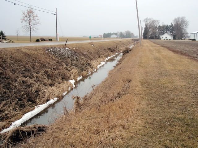
So, enough about that. The first site I selected was a drainage ditch that is a direct tributary to the North Branch of the Portage River.
Date: February 26, 2009
Location: unnamed tributary of the North Branch of the Portage River in Portage Ohio.
Water Level: discharge rates on the Portage River mainstem much further downstream showed discharge to be lower than normal for this time of year with discharge at around 220 cfs (average is 325 cfs). Much of the ditch was shallow, ranging from 0.1m to 0.3m in depth.
Water Temp.: estimated to be around 1-2*C (some ice still along the edges of the stream)
Water Quality: this highly modified drainage ditch was heavily silt laden. There are many drainage tiles coming off fields that had visible discharge going into the stream.
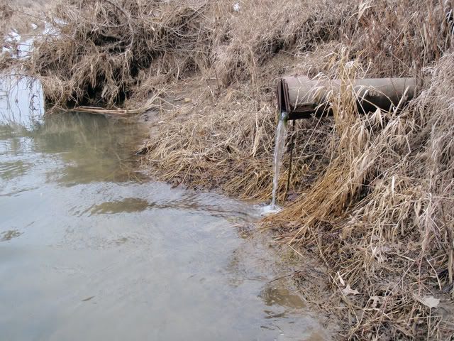
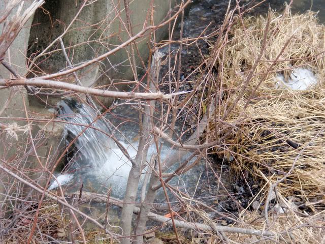
Substrate: the straightening of this channel, and the surrounding land use have undoubtedly contributed to a heavy silt load in the stream visible on all the substrate.
the substrate consisted of heavily silted sand and muck. There was a grass line along the edges of the stream with a few small trees still intact. One man-made riffle existed downstream of a bridge.
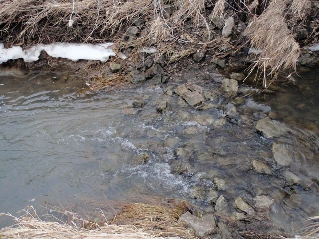
the man-made riffle accounted for some of the only riffle-dwelling species of fish encountered in the stream. Limited spawning and feeding habitat probably lead to fierce competition (inter and intraspecific).
Collected:
Goldfish (Carassius auratus)
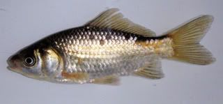
- an exotic species that can be found in high densities in ditches of the Portage River Watershed. Although we only collected 1 this time, other visits to this ditch have yielded dozens. They can adapt well to a wide variety of water parameters but arent abundant when fish species diversity is high. The presence of these fish suggests a highly disturbed aquatic ecosystem.
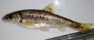
Creek Chub (Semotilus atromaculatus) - a generalist species usually found in smaller streams and headwaters. Oftentimes, these fish are the most abundant species found in smaller streams. They can thrive in a wide range of water conditions and are strong competitors with other fish. Creek Chub have large mouths and large adults are piscivores. These fish seem to one of the top predators in this ditch.
Bluntnose Minnow (Pimephales notatus) one of the most common fish in low-gradient streams of the Midwestern U.S. These fish thrive in waters that are eutrophic and where competition between other species is low. These fish were the most abundant fish sampled. Looking at their rounded/blunt snout, its easy to see where their name came from.
Fathead Minnow (Pimephales promelas) a species commonly sold as bait to fishermen and as feeder fish in pet shops. These fish are extremely tolerant of poor water conditions. Fathead Minnows are used by scientists for bioassays where they can test certain chemicals (among other things) on these fish. The idea being that if it harms Fathead Minnows, it will surely harm other fish. In many parts of the country, Fathead Minnow populations exist due to introductions from bait buckets, but these fish are naturally occurring in the Portage River Watershed.
Striped Shiner (Luxilus chrysocephalus)
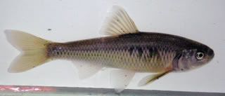
a larger species of shiner found in the Portage River Watershed. We didnt find these fish in great numbers. They arent as tolerant of poor water quality as the other species found in the ditch. A useful tip for identifying species from this genus of minnows (Luxilus) is that these fish have the scales nearest to their gills taller than they are wide.
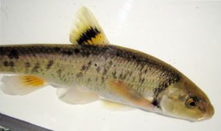
Central Stoneroller (Campostoma anomalum pullum)
a species of fish that does quite a bit of feeding on periphyton that accumulate on rocks. Periphyton doesnt grow well on rocks that have lots of silt on them. This would mean that there would need to be an area where there are rocks that dont have much silt on them for Stonerollers to be present and thriving. The only place on the ditch we found Stonerollers was directly below the man-made riffle. Without this riffle, it is likely Stonerollers would not be present in this ditch. The females were gravid and the males were just starting to develop tubercules. If you look close at the head of this fish, youll see some white areas where tubercules are starting to form.
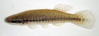
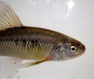
Blackstripe Topminnow (Fundulus notatus) a native Killifish. These fish inhabit the surface areas of this ditch and are very abundant. They are found in low-gradient streams throughout much of the Midwestern U.S. Im closely monitoring their presence in streams due to the fact that they compete directly with the state endangered Western Banded Killifish (Fundulus diaphanus menona) for food and habitat. The presence of Blackstripe Topminnows so far have shown the absence of Western Banded Killifish in the Portage River Watershed.
Yellow Bullhead (Ameiurus natalis) a small catfish species that is not too particular of water quality. A few small ones were found in the flooded vegetation.
Largemouth Bass (Micropterus salmoides) one small one (around 3 inches) was caught along some flooded vegetation. Its not likely that these fish persist in this ditch very long. In the spring and early summer these ditches may provide a nursery area for small developing Largemouth Bass due to their abundant vegetation, plankton, and small fish.
Green Sunfish (Lepomis cyanellus) one of the most ecologically tolerant species of Sunfish found in Ohio. They do reside in most streams in the state and compete well with other species.
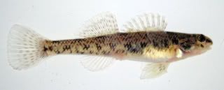
Johnny Darter (Etheostoma nigrum) a small, bottom-dwelling species of fish found in low-gradient streams throughout the state. Johnny Darters can exist in streams that most other Darter species cannot. In the main stem of the Portage River, Ive found Smallmouth Bass to be quite fond of Johnny Darters. On more than one occasion Ive caught Smallmouth Bass that have had Johnny Darters hanging out of their mouths.
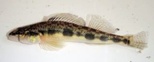
Blackside Darter (Percina maculata) - this is another species of darter that lives in low-gradient streams. Many of the fish we caught were gravid (not the one pictured though probably a male). These fish are much more commonly found in the main stem of the Portage River and may only ascend these ditches in the spring to spawn.
Notes: The species of fish found in this ditch are mostly characteristic of a low-gradient stream of the Midwestern U.S. that has been highly altered. We sampled the ditch with an 8 by 4 seine and only spent about an hour collecting fish. Had we had more time, Im sure we would have been able to find more species of fish, however, in this type of habitat many more do not usually exist. The Stonerollers are a great example of the theory that increasing the number of niches available can increase the number of species present.
This is the first of many sites that will be sampled. I hope you've enjoyed and will continue to read as I sample some more.
(p.s. This is being used for a project where I'm presenting some of the information to people who haven't seen much about these organisms before, please excuse any of it that's a bit repetitive or common knowledge).