So I have been trying to wrap my head around the dispersal avenues created by glaciation, primarily in the Northeast. Many literature sources that explain dispersal through glacial outlets do a good enough job at describing these events. But... I just am not grasping the whole picture. I guess my point is... Has anyone come across a 3D model of presumed advance and retreat of glaciers and their impact on geography and opening or closing of outlets? It would definitely help a slow learner like me!!
Glaciation and dispersal outlets
Started by
Guest_darter1_*
, Apr 02 2010 07:50 AM
17 replies to this topic
#2
 Guest_farmertodd_*
Guest_farmertodd_*
-

- Guests
Posted 02 April 2010 - 11:11 AM
I've put together this for the Ohio Region. The rivers in Michigan besides the Grand River are hypothetical, as are the post-Warren closed basin streams.
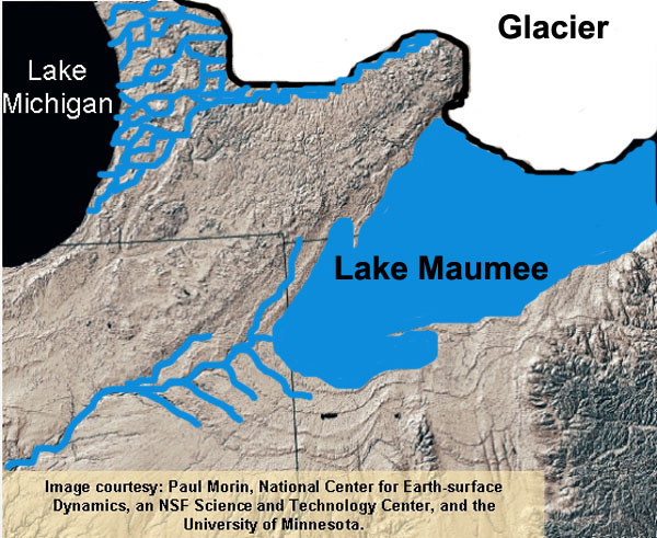

I am going to redo them with my own digital elevation model and etc so I don't have to have the big ugly citation on there and I can use the new 30 sec DEM to accurately map the Grand River outlet. I don't know if I'll go that far east however.
I also didn't address the capture of the St. Marys and St. Joseph Rivers by the Maumee in these graphics, which potentially brought a majority of species.
For what you're looking for, you might look into literature from oil exploration off the coast. A lot of the refugia up there was out on the continental shelf.
Todd
Todd
Edited by farmertodd, 02 April 2010 - 11:12 AM.
#3
Guest_FirstChAoS_*
Guest_FirstChAoS_*
-
- Guests
Posted 03 April 2010 - 07:14 AM
I have been trying to find information on post-glacial northeastern colonization by freshwater fish myself and the information is scarce.
A History of Fishing in New Hampshire got me most of it. After the glaciers the first fish in the region came in from the sea. Smelt, Salmon, Char, Brook Trout. They came in waves too. What the book calls the "ancestral char" settled before the brook trout and could survive competition in a few ponds that brook trout could not reach by the time they got here due to water levels of post-glacial waterways receding. Most warmwater fish came later and were largely restricted to the southern parts of the Connecticut and Merrimack drainages. Most of the so called warmwater ponds were brook trout ponds once until settlers introduced perch and pickerel into them if that book is right. ("A History of Fishing in New Hampshire" is a great book, though a more accurate name for the book would be "A History of Environmental Change and Human Impact in New Hampshire")
Species many consider native such as bass, walleye, and pike were actually not a part of the native new england fish fauna and were instead introduced from elsewhere by human activity in relatively modern times.
Other information is sketchy at best and was gleaned from web sites (which I wish I bookmarked so I could use them as examples here).
Among the tidbits I found on websites were:
- During the ice age a large part of what is now under ocean in the Gulf of Maine was dry land, and the waterways in this land may have been a refuge for some of the more coastally distributed freshwater fish species such as swamp darters and redfin pickerel.
- A connection once existed between the connecticut and hudson rivers and fish could cross on it, this is part of why the hudson river has three subspecies of tesselated darters in it.
- the warmwater fish of new england such as pumpkinseed, redbreast sunfish, yellow perch, chain pickerel, and bullhead largely spread north from new jersey.
- The colonization of waters west of new england also came in waves, whatever connection linked the waters west and each of the appelachians closed before species such as smallmouth bass or walleye reached the area.
- inland lakes and ponds once had a variety of cyprinid species, it's the introduction of the golden shiner (which may have been native to the connecticut drainage) to ponds as fishing bait that reduced the diversity.
I am not sure the accuracy of these snippets of info I found online though.
#4
Guest_fundulus_*
Guest_fundulus_*
-
- Guests
Posted 03 April 2010 - 11:26 AM
During peak glaciation about 18,000 years ago it's true that much of the New England coast would have been much to the east of the current position. But much of that land had deep ice sheets on it, and any land on the edge of that would have been arctic tundra that would not have supported any of the fish species currently found on the New England coast; they would have been no further north than what is now Chesapeake Bay, which would have had the climate of modern southern Ontario. Recolonization only became possible with significant glacial retreat starting about 13,000 years ago, punctuated by spectacular catastrophes like ice-dammed water bursting out to the south or east from the modern Great Lakes region or upper Connecticut River. New England is still recovering from the last glaciation, especially north of Cape Cod.
#5
Guest_darter1_*
Guest_darter1_*
-
- Guests
Posted 05 April 2010 - 07:42 AM
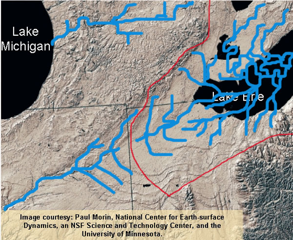
Interesting stuff... But again, I am not familier enough with each drainage to grasp the big picture. I understand the process, but without a diagram or model I am still lost. I am in PA and fairly familier with all the drainages here but still can't grasp these as well as I would like. Thanks for the images Farmertodd, those helped, the last slide, is that showing the previous drainage before the creation of Lake Erie?
I will keep looking in to the pubs that have been listed. If I can add one to the list, Trautman has a fairly decent synopsis in the Fishes of Ohio. But like normal, alot of it is over my head, since I am not familier with the area or current drainages.
I will keep looking in to the pubs that have been listed. If I can add one to the list, Trautman has a fairly decent synopsis in the Fishes of Ohio. But like normal, alot of it is over my head, since I am not familier with the area or current drainages.
#6
Guest_farmertodd_*
Guest_farmertodd_*
-
- Guests
Posted 05 April 2010 - 11:25 AM
Hi Darter,
Yes, the last image is a hypothetical drainage network in the closed basin that occurred post-Warren (which drained catastrophically down the Mohawk and Hudson). There is evidence that it sat isolated like this for almost 5,000 years. Good place for a species such as the blue pike to evolve (wink wink, nudge nudge).
Any yep, for those who don't know... Lake Erie formed as isostatic rebound lift the Niagra Escarpment. When you think about that gorge getting cut in only a couple thousand years, it's pretty mind blowing. What's even more neat, I think, is that eventually, the river will cut through the Escarpment, the lake will drain, and you'll have that really long deep gorge that the "Erie River" will flow off into. Be some really good farmland here in the western basin, since that's where we've washed all our soil.
Todd
#7
Guest_darter1_*
Guest_darter1_*
-
- Guests
Posted 05 April 2010 - 12:53 PM
Sorry Todd, my computer just went crazy for a bit. Thanks for the info! I didn't realize Erie was formed by rebound, I assumed it was a retreating glacier. This puts more questions in my head. The switch from lotic to lentic would have played a big part in distribution. The first species to run away from that environment (gravel spawners and riffle dwellers) might have had different options open for dispersal than later distributions. Nocomis are in the back of my head... N. biguttatus has a wierd distribution in PA. HHmmm?
Makes me wish that 3D model was out there somewhere, it would be so cool to see windows open and close for dispersal... even if it was hypothetical... it may show something that others have overlooked.
Makes me wish that 3D model was out there somewhere, it would be so cool to see windows open and close for dispersal... even if it was hypothetical... it may show something that others have overlooked.
#8
Guest_farmertodd_*
Guest_farmertodd_*
-
- Guests
Posted 05 April 2010 - 01:22 PM
Yep, not a drop of meltwater, except what came down from the upper lakes in Lake Agassiz, and was still stored in those basins. It was filled initially with local precipitation.
N. biguttatus an interesting example, as are E. exile, E. microperca, N. dorsalis, N. heterolepis, N. heterodon, F. diaphanus menona and some others that presumably moved west like C. elongatus and Chrosomus erythrogaster. There's a bunch of weird disjuncts in Michigan too that may have been over in eastern Ohio, and were overlooked before we rearranged their habitats.
Was also talking with someone this weekend who for all practical purposes caught lesser siren in Ashtabula County in the 50's and 60's. He had no reason to make this up, described it as "a weird eel-looking fish with two small legs - what the heck was that??" So there's no voucher (even photo), unfortunately, but I think it's a pretty darn strong anecdote. I showed him a pic and he about fell over (as did I).
It's all very interesting to think about
Todd
#10
Guest_Newt_*
Guest_Newt_*
-
- Guests
Posted 05 April 2010 - 02:17 PM
Was also talking with someone this weekend who for all practical purposes caught lesser siren in Ashtabula County in the 50's and 60's. He had no reason to make this up, described it as "a weird eel-looking fish with two small legs - what the heck was that??" So there's no voucher (even photo), unfortunately, but I think it's a pretty darn strong anecdote. I showed him a pic and he about fell over (as did I).
Todd
That's not entirely surprising. Siren intermedia has a weird, spotty northward extension from its coastal plain core range up the Wabash valley and continuing to the southern Lake Michigan drainage in NW Indiana and SW Michigan. Similar patterns can be seen in the central newt (Notophthalmus viridescens louisianensis), the eastern group of the plainbelly water snakes (Nerodia e. erythrogaster, N. e. flavigaster, and N. e. neglecta), the eastern mud turtle (Kinosternon s. subrubrum), and the western ribbon snake (Thamnophis p. proximus). These are all species with a preference for more-or-less permanent riverine and upland wetlands.
Is it likely that there was a lot of coastal-plain-like habitat in the midwest during glacial retreats? It seems to me that the combination of freshly deposited till and lots of meltwater would likely result in some spectacular swamps, but I have no clue what evidence there might be for such things.
#11
Guest_farmertodd_*
Guest_farmertodd_*
-
- Guests
Posted 05 April 2010 - 02:50 PM
Newt,
Thanks. Depending on climate, there'd been a huge extent of productive marshlands for the very reasons you suggest. If it were cooler, there'd been a lot of northern muskeg, but the timing of things was great for these critters... The climatic maximum co-occurred around the closed basin of Erie period during the "prairie penninsula" phase when western community spread eastward. Things persist where local conditions allowed.
I'm glad to have this extra list of critters to drop into the equation.
What'll really run yer noodles is the Atlantic coastal plain disjunct plants that presumably made it up the Hudson Valley, into the Great Lakes coasts and made their way on over to Illinois. Cross-leaved milkwort (Polygala cruciata) is a great example.
Todd
#12
Guest_FirstChAoS_*
Guest_FirstChAoS_*
-
- Guests
Posted 10 April 2010 - 12:30 AM
some interesting glacial lake info I found for the northeast.
Glacial Lake Hitchcock (Connecticut river valley). http://www.bio.umass.../hitchcock.html and a few others.
An article on Sculpin in lake Hitchcock http://www.sciencedi...4c924f928e8b785
and lastly this book excerpt
http://books.google....mpshire&f=false
this article briefly mentions a variety of glacial lakes in New Hampshire including glacial lake Ashuelot, contoocook, merrimack, winnipesaukee, coos, and colebrook. Given how sprawling the glacial lake winnepesaukee was (covering NH's lake region including lake winnepasaukee itself) it's suprising it is not on the map with hitchcock in the first article, maybe the lakes existed at different times.
Also this article which mentions evidence of the lake under connecticut river, and that long island sound itself was once a glacial lake, plus a bit about bloodworms http://www.bio.umass...r/varvepub.html
Sorry I keep editing to add links, this one is a PDF about fish trace fossils and refugia in new england. http://gsa.confex.co...cgi?uploadid=82 I find the "mystery" of the sculpin species odd as much of new england (and all of new hampshire) has only the slimy sculpin.
I remember when I was in college I asked to do an excavation of the sediments of lake ashuelot (the college is on top of it as it stretched from Winchester to Keene) to find traces of pollen and fish to do a time line of life entering NH post glaciation and my professors and everyone else I talked to said no.
Edited by FirstChAoS, 10 April 2010 - 12:58 AM.
#13
Guest_Newt_*
Guest_Newt_*
-
- Guests
Posted 12 April 2010 - 11:00 AM
What'll really run yer noodles is the Atlantic coastal plain disjunct plants that presumably made it up the Hudson Valley, into the Great Lakes coasts and made their way on over to Illinois. Cross-leaved milkwort (Polygala cruciata) is a great example.
Todd
What are the chances that that plant actually dispersed from a western refugium and then made its way down the east coast? Seems like a wind-dispersed plant like a milkweed would have a really tough time expanding against the prevailing winds. Has anyone looked at population genetics in that species?
*EDIT* Oh, milkwort, not milkweed. USDA Plants shows a pretty broad distribution for this thing; where's the evidence that it moved up the Hudson and westward, rather than northward?
#14
Guest_FirstChAoS_*
Guest_FirstChAoS_*
-
- Guests
Posted 13 April 2010 - 10:37 PM
The more I learn the more confusing it gets.
It makes sense that since both the connecticut and hudson rivers flowed into glacial lake connecticut (long island sound) at least when they were not lakes themselves, and that refugiums were mainly in areas that are now offshore according to maps on sites linked and fish seem to have distributed by moving around towards lake connecticut and up, that the hudsom and connecticut share alot of species, and they do. But the Hudsom also shares alot of species not found in the connecticut.
Did the hudson have more sources of fish introduction than just that one refuge that ended up connecting to glacial lake connecticut?
Stranger still the Androscoggin river in northern NH and Maine has a couple fish listed that are not listed in the other two rivers such as finescale dace. (oddly pearl dace are listed in the hudson and androscoggin but not the connecticut).
Also should I assume fish whose range in new england is limited to the northernmost parts and deep cold water bodies such as lake and round whitefish, burbot, lake chub, finescale dace, and longnose suckers were earlier migrants to the region than the more southern distributed species? Their cold tolerance could have allowed them to follow the glaciers retreat earlier.
Edited by FirstChAoS, 13 April 2010 - 10:38 PM.
#15
Guest_AussiePeter_*
Guest_AussiePeter_*
-
- Guests
Posted 14 April 2010 - 10:58 AM
The more I learn the more confusing it gets.
That statement reminds me of a funny quote that I've always liked. Couldn't find the actually correct wording, but it goes something like the smart people realize how little we know, the stupid people think we know everything. The first half of that is a common quote, but I like the stupid part added to it.
And another good one to remember with anything biogeographical.
Believe those who are seeking the truth; doubt those who find it.
Trying to comprehensively understand all that went on during deglaciation is a fun exercise, but is one that can never make full sense as we just have no way to really know what went on. Why did species X occur here, but not there? There are so many stochastic factors that go into species colonizing new habitats that it starts to defy reasonable explanations. Be skeptical of everything biogeographic, as most of it is almost certainly wrong. And I call myself a biogeographer too!
Cheers
Peter
#16
Guest_farmertodd_*
Guest_farmertodd_*
-
- Guests
Posted 14 April 2010 - 11:58 AM
USDA Plants shows a pretty broad distribution for this thing; where's the evidence that it moved up the Hudson and westward, rather than northward?
Look at the state by state distributions. The US map doesn't tell you diddly. It may have persist in the Kankakee Sands during the Wisconsian, but I'd say that's pretty unlikely. Also, it's not wind dispersed.
And Peter is dead on. People have the impression that scientists know everything, but that generally only applies to some Physicists and Chemists (of which traditions said we'd know "everything" by the 1930's). Most ecologists I know fully admit we've only scratched the surface, and it's much worse once you get under the water!
Todd
#17
Guest_dmarkley_*
Guest_dmarkley_*
-
- Guests
Posted 15 April 2010 - 12:22 PM
Well this chemist certainly doesn't know everything!Look at the state by state distributions. The US map doesn't tell you diddly. It may have persist in the Kankakee Sands during the Wisconsian, but I'd say that's pretty unlikely. Also, it's not wind dispersed.
And Peter is dead on. People have the impression that scientists know everything, but that generally only applies to some Physicists and Chemists (of which traditions said we'd know "everything" by the 1930's). Most ecologists I know fully admit we've only scratched the surface, and it's much worse once you get under the water!
Todd
LOL
Dean
Reply to this topic


2 user(s) are reading this topic
0 members, 2 guests, 0 anonymous users

