I have revamped the map interface of the site mainly due to the deprecation of the Google Earth API. It now uses standard Google Maps and loads much faster without the need of any plugin (it will also load on mobile browsers now). You can still download the KMZ files and load them into Google Earth as needed.
I have also added location collection data from FishNet 2 using their API and layering onto the watershed maps. Working on adding KML downloads for the points as well as CSV data dumps.
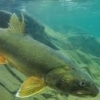
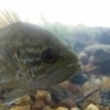
Example: Yoke Darter - http://fishmap.org/s...oke-Darter.html
 Untitled.png 251.38KB
0 downloads
Untitled.png 251.38KB
0 downloads
I have noticed some issues - there is a limitation in loading KMZ files over 3MB so certain species with huge ranges will not display watershed maps (Smallmouth Bass, etc) until I figure out a work around. Again, you can simply download the KMZ for Google Earth until I fix it. It will still show you the collection information though.
I am also still working on adding current ranges versus native watersheds.
If anybody uses the site, let me know any issues or suggestions you have as I am actively still developing and testing.
Ryan
P.S. - thanks Ben C. for the testing and feedback