All good its understandable. These things happen haha

FishMap.org site update
Started by
rc6750
, Mar 04 2015 04:46 PM
37 replies to this topic
#21

fishlvr
-
- NANFA Guest
- Savannah, GA
Posted 08 May 2015 - 11:55 AM
Steve Knight
Lower Ogeechee/Ogeechee Coastal Drainage
Lower Ogeechee/Ogeechee Coastal Drainage
#22
rc6750
-
- NANFA Member
- Tampa Bay, FL
Posted 12 May 2015 - 09:41 AM
OK - so I think I have resolved the issues and the server seems stable now. I will continue to monitor but please let me know if you see any other issues.
#23
olaf
-

- NANFA Member
Posted 28 May 2015 - 10:52 PM
I just spent some time on the site and have to say again: WOW! What an awesome resource you've created. It's astonishing.
Redhorse ID downloads and more: http://moxostoma.com
#24
Kanus
-
- Board of Directors
-

Posted 29 May 2015 - 11:31 AM
I'd like to just remind you what a valuable resource this is for professionals as well. I'm planning a fish survey of the upper PeeDee drainage in Virginia this summer and your site was invaluable for putting together a list of potential species we might see to use as a reference.
Derek Wheaton
On a mountain overlooking the North Fork Roanoke River on one side, the New River Valley on the other, and a few minutes away from the James River watershed...the good life...
Enchanting Ectotherms
My Personal Facebook (mostly fish related, if you'd like to add me)
#25
Mysteryman
-

- NANFA Guest
Posted 29 May 2015 - 12:31 PM
Is there a way to input a body of water or geographical area and see what fish we might expect to find? That would be the best thing ever... " Let's see... where am I? Ok... what's in this creek?...... ah! Cool. That's worth climbing down the bank to investigate! "
#26
rc6750
-
- NANFA Member
- Tampa Bay, FL
Posted 29 May 2015 - 12:53 PM
Olaf/Kanus - great! Glad you guys are finding the site useful - let me know any suggestions or issues.
MysteryMan - I am working on some very early beta testing right now for using GPS location services on a smartphone to get the watershed of where you are standing - this would in turn let you know what is in the area by watershed and collection data. I don't have any data lower than watershed though so until that dataset is available I won't be able to tell you whats in a particular stream, but you could extrapolate and explore. This is all very early and testing/experimenting - it could not work out thought, just an FYI,
On the website now you can currently enter a zip code and get the watershed(s) for that zip and drill down, but I am hoping to use location services as a more detailed mobile version..,
updates later.
#27
CCat
-

- NANFA Member
- Denver, CO
Posted 29 May 2015 - 04:46 PM
It's been a great resource for me too -- I used it this week when planning our summer trip from Denver to North Carolina. (What could I expect to find here? and here? and here?) The zipcode-to-watershed search was really helpful. I found myself wishing to click the species name (in the list below the watershed map) and see more details on the fish -- a way to get a quick picture + species detais. e.g., on this page:
http://fishmap.org/w...190004,10190002
...like a link to the fishbase listing, or wikipedia entry, or even a google search. Clicking the species name and seeing the map is useful, but wasn't the first thing I wanted to do.
I'm a web developer by trade, I can see how much work you've put into aggregating all this data & the various integrations. It's incredible!
#28
rc6750
-
- NANFA Member
- Tampa Bay, FL
Posted 29 May 2015 - 09:22 PM
That's actually a pretty good idea. Maybe I will add some sliding divs under each fish with the same links as on the species page or something. I will check into it.
#29
rc6750
-
- NANFA Member
- Tampa Bay, FL
Posted 10 June 2015 - 11:19 AM
It's been a great resource for me too -- I used it this week when planning our summer trip from Denver to North Carolina. (What could I expect to find here? and here? and here?) The zipcode-to-watershed search was really helpful. I found myself wishing to click the species name (in the list below the watershed map) and see more details on the fish -- a way to get a quick picture + species detais. e.g., on this page:
http://fishmap.org/w...190004,10190002
...like a link to the fishbase listing, or wikipedia entry, or even a google search. Clicking the species name and seeing the map is useful, but wasn't the first thing I wanted to do.
I'm a web developer by trade, I can see how much work you've put into aggregating all this data & the various integrations. It's incredible!
Added the species links (Roughfish, ITIS, FishBase, NatureServe, USGS NAS, Wikipedia, and Google Image search) below each species on the watershed page now so that you do not need navigate away from the watershed to lookup the info on them. Just a quick change I made, let me know if it helps or any other feedback.

#30
CCat
-
- NANFA Member
- Denver, CO
Posted 10 June 2015 - 09:40 PM
Looks great Ryan - that really helps me explore a watershed quickly. Thanks!
#31
Isaac Szabo
-

- NANFA Member
- Marble Falls, AR
Posted 28 July 2015 - 12:03 PM
The "Click any spot on the map to load watershed" has not been working for me for a little while now. When I click on it, I get "document.write("Missing or Invalid API key." );". I thought I would mention it just in case you are not aware of it.
#32
rc6750
-
- NANFA Member
- Tampa Bay, FL
Posted 28 July 2015 - 12:31 PM
Yikes - sorry - fixed. Yeah - please let me know anything you have issues with. thanks!
#33
rc6750
-
- NANFA Member
- Tampa Bay, FL
Posted 23 September 2015 - 03:33 PM
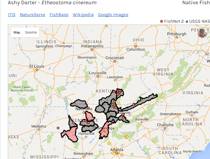
Some new updates were just rolled out:
- Removed KML files - the site now uses compressed geoJSON which are much smaller and easier to manipulate in Google Maps.
- All species with watershed data now show on the maps screen. Before certain species would not have KML files. This has been resolved.
- Watersheds now have different colors for different types. Historic watersheds show as red, native range watersheds show as gray, and new ranges (including exotic non native species) show as green. I am not 100% sure about the color choices, give me some feedback on what you would like to see.
- Updated some text pages
Features coming soon:
- CSV download of USGS NAS data, similar to the FishNet 2 data download
- Citation information
- I am developing an API (with testing from NCFishes site) for map embedding on remote sites. Look for this feature soon.
- Ability to toggle USGS and FishNet 2 data points on and off
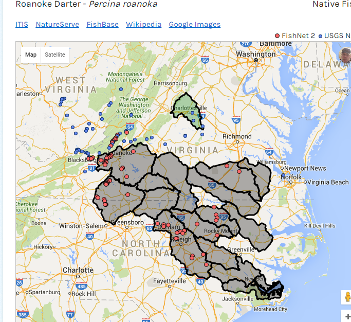
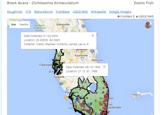
Some screenshots:
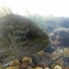
1- Ashy Darter range show historic ranges in red
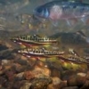
2- Black Acara invasive showing range in green from USGS NAS
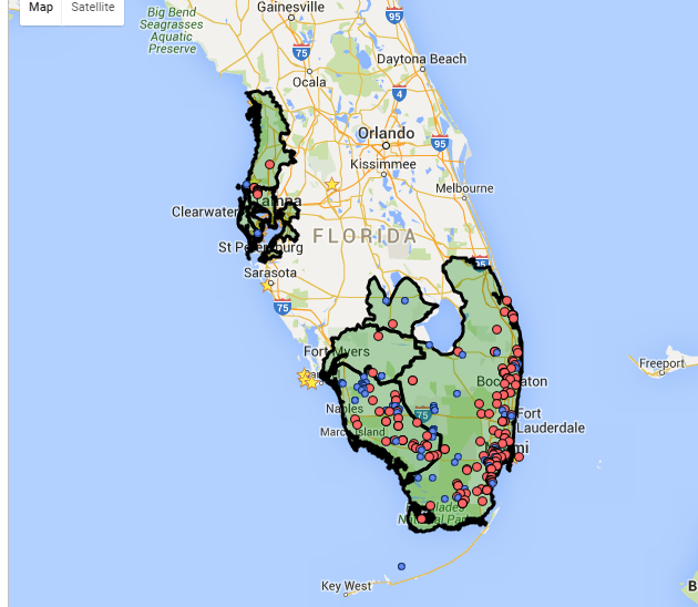
3- Roanoke Darter showing range along with green user reported watershed
Just as a side note - I am still working on getting FishMap.org moved over and branded for NANFA. Once this process is done I will start the development on user submitted collection.
As usual - let me know if there are any issues, feedback, etc
Ryan
#34
Matt DeLaVega
-

- Forum Staff
- Ohio
Posted 23 September 2015 - 04:08 PM
Wow. This looks like a lot of work Ryan. Remember that you have nearly a half dozen volunteers, so call on them if you need some help that they can be tasked with. I am happy to help facilitate, but that is about all, helping run this forum challenges my tech skills. Good job man!
The member formerly known as Skipjack
#35
olaf
-
- NANFA Member
Posted 23 September 2015 - 05:47 PM
You'll be making user submitted and invasive ranges different colors, I assume.
Looks amazing, and like a ton of work.
Redhorse ID downloads and more: http://moxostoma.com
#36
Isaac Szabo
-
- NANFA Member
- Marble Falls, AR
Posted 23 September 2015 - 07:20 PM
Awesome work Ryan! I like your updates!
Also, I have a couple of suggestions:
1. I would like the "Find Species" search to work with both common and scientific names. There have been many times that I have typed in a scientific name, gotten no results, and then had to go back and type the common name.
2. I think it would be nice if clicking a dot on the map provided more information than just the collection date. The main thing that I know you have for every record is the lat long coordinates. This would make it easier to transfer a desired location to a personal map. Otherwise, things like waterbody name, number of species collected, or other notes could be nice, but I realize you won't have that information for all records.
#37
rc6750
-
- NANFA Member
- Tampa Bay, FL
Posted 24 September 2015 - 08:52 AM
Wow. This looks like a lot of work Ryan. Remember that you have nearly a half dozen volunteers, so call on them if you need some help that they can be tasked with. I am happy to help facilitate, but that is about all, helping run this forum challenges my tech skills. Good job man!
Haha - don't worry when I get to that part I will lean heavily on the volunteers ![]() .
.
You'll be making user submitted and invasive ranges different colors, I assume.
Looks amazing, and like a ton of work.
Yeah - the user submitted points will be a different color dot.
1. I would like the "Find Species" search to work with both common and scientific names. There have been many times that I have typed in a scientific name, gotten no results, and then had to go back and type the common name.
2. I think it would be nice if clicking a dot on the map provided more information than just the collection date. The main thing that I know you have for every record is the lat long coordinates. This would make it easier to transfer a desired location to a personal map. Otherwise, things like waterbody name, number of species collected, or other notes could be nice, but I realize you won't have that information for all records.
Good suggestions.
1. Done.
2. Done. For now I just have Date, Location, and if available Collector. See below
#38
Isaac Szabo
-
- NANFA Member
- Marble Falls, AR
Posted 24 September 2015 - 09:21 AM
Wow, that's great! Thanks!


0 user(s) are reading this topic
0 members, 0 guests, 0 anonymous users

